 Read About Residential Water Use in Tucson, Arizona MSA
How are we doing?
Residential Water Use in Gallons per Capita per Day (GPCD) in 2020

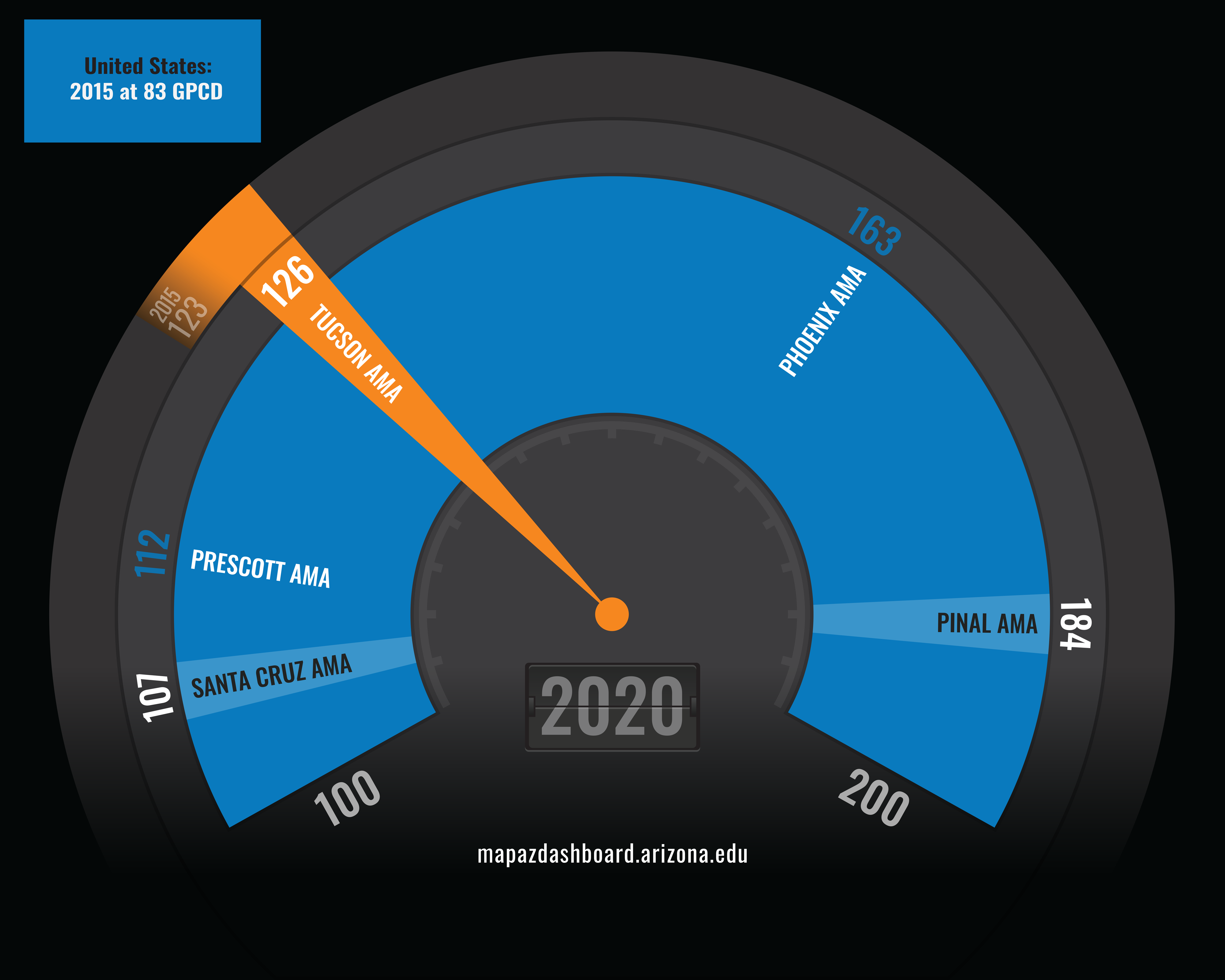
Tucson ranked in the middle of Arizona's Active Management Areas (AMAs) in residential water use. The Tucson AMA includes portions of Pima, Pinal, and Santa Cruz counties and contains five incorporated cities and towns (Tucson, South Tucson, Oro Valley, Marana, and Sahuarita). In 2020, the Tucson AMA's residential customers used 126 gallons per capita per day (GPCD) of water. The Santa Cruz AMA reported the lowest rate at 107 GPCD, while the Pinal AMA reported the highest at 184 GPCD. The Tucson AMA reduced their residential water use by 41 GPCD or 24.6%, from 2000 to 2020.
In 2015, Arizona ranked eighth among the western states in residential water use. Arizonans used 146 GPCD in 2015, 63 more GPCD than the U.S. average. All the western states, except Texas and New Mexico, used more water per capita each day than the national rate. New Mexico and Texas tied for the lowest amount of residential water usage at 81 GPCD, while Idaho had the highest rate at 186 GPCD. The western states tend to have high rates of water use due to their hot and dry climate. The U.S. Geological Survey reports state and county-level data every five years. The 2020 data will be available in 2025.
Why is it important?
Water is a finite resource with constant pressure on its availability, especially in the western U.S., where rapid population growth and a decades-long drought have placed additional pressure on an already strained resource. Water is used for residential, agricultural, commercial, and industrial purposes. The United States Geological Survey reported that an estimated 283 million people relied on public-supply water for their household use in 2015. That represents about 87% of the total U.S. population.
Arizona's AMAs were created to manage the state's water resources in regions that relied heavily on mined groundwater. The Tucson AMA has a goal of reaching safe-yield by 2025. Safe-yield is a management tool that attempts to maintain a long-term balance between the amount of groundwater withdrawn and the natural and artificial recharge. Arizona has six Active Management Areas (AMAs). The Arizona Department of Water Resources reports data for five of the six AMAs. The Douglas AMA was designed as an AMA in December 2022, data is not yet available.
How do we compare?
Arizona's water sources include the Colorado River, other in-state rivers (Salt and Verde River systems), groundwater, and effluent (reclaimed water). In 2020, 36% of Arizona's water was supplied by the Colorado River, 18% by other in-state rivers, 41% by groundwater, and 5% by effluent. The share of water from each of these sources varies drastically between the AMAs. For example, within the Tucson AMA, 69.8% of the water supplied comes from the Colorado River, 15.3% from groundwater, and 14.9% from effluent. No other in-state rivers contribute to the Tucson AMA's water supply. In the Santa Cruz AMA, groundwater is the sole source of water. The Pinal and Prescott AMAs rely heavily on groundwater as well. Supply data is available for all the AMAs in the drop-down menu. Click on a name to compare the other AMAs to Tucson.
What are the key trends?
The city of Tucson has dramatically reduced residential water usage during the past two decades, from a high of 121 gallons per capita per day in 1996 to only 76 GPCD in 2022. That is a reduction of 45 GPCD, or 37.2%, over 26 years. The city of Tucson has been proactive in encouraging water conservation by offering a wide range of rebates and incentive programs to residential and commercial customers. Arizona’s residential water use has remained relatively constant between 1985 and 2015 with only slight fluctuations. The U.S. reported a modest decrease of 22 GPCD in residential water use during this period, a 21.0% decline. To view data for the Tucson and Phoenix AMA click on the grayed-out geography name. Data for all AMAs, States, and Arizona counties can be found on the comparison page.
How is it measured?
The U.S. Geological Survey’s (USGS) National Water-Use Information Program compiles and publishes water-use data. The USGS works in cooperation with local, state, and federal environmental agencies to collect water-use information. The USGS typically reports water usage data for the U.S., states, and counties every five years. Tucson Water provides current and historic water data for its service area through its annual report. Data for Arizona's Active Management Areas can be found on the Arizona Department of Water Resources AMA Dashboard.


